| |

|
|
|
| |
 The name Sandhurst in Kent means simply a place which is
mostly wooded in sandy ground.
It occupies a low ridge, surrounded possibly as
late as the Norman conquest with sea-water estuaries,
at least at high tide. The ridge ends at Newenden ,
where floods have shown what the land and sea may
have looked like in the past.
The hill on which Downgate is built, near the church,
is the highest point in the parish, this is to the
south of the main road towards Hawkhurst . The name Sandhurst in Kent means simply a place which is
mostly wooded in sandy ground.
It occupies a low ridge, surrounded possibly as
late as the Norman conquest with sea-water estuaries,
at least at high tide. The ridge ends at Newenden ,
where floods have shown what the land and sea may
have looked like in the past.
The hill on which Downgate is built, near the church,
is the highest point in the parish, this is to the
south of the main road towards Hawkhurst .
The main road from London to Rye runs through the village.
The other principal routes from Hastings and Maidstone
meet at a staggered crossroads in the village. These
roads are the modern re-alignment of the Roman route
from Beauport near Battle to Rochester and in places
follows its actual line. The original Roman road surface
lies two feet below the present ground level. It has been
exposed more than once in recent years, and the track
is partly visible from the air.
The history of Sandhurst is fairly scanty. It is
probable that the village would have been called on
to provide for the defenders on their way to the
Battle of Hastings in 1066 , and later, the survivors
retreating to London.
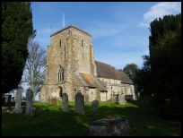
The church of St Nicholas was completed by the time of
the Black Death in 1348/49. The church and the main
part of the village are widely separated. The main part
of the village used to be near the church, however,
local tradition has it that due to the number of plague
victims buried in the churchyard, the remaining
inhabitants sought a healthier site on which to live!
A factor in favour of a move to the north-east was
probably the increasing importance of the ridge road
as a way to Rye , one of the ancient Cinque Ports .
In 1331 the export of unwashed wool was prohibited by King Edward III. He
encouraged weavers from Flanders to settle here, thus bringing their
weaving and dying techniques to England. Sandhurst has a couple of
houses which were used by the weavers.
There are many houses in and around the village
dating from the 15th to the 18th centuries, some
still retain their original exposed timber frames.
Others have been 'modernised' by tile-hanging, thus
obscuring their early date. The church sports a good
example of a mounting block used by ladies with long
skirts to get onto their horses.
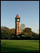
Near the north side of the Rye road stands the brick
base of a fairly unique 'five-sailer' smock windmill,
this is being rebuilt into a power generating windmill
which will look similar to the original. |
|
 The road from Sandhurst in Kent towards Newenden , runs along
the ridge with wide views across the valley to the
North. The road from Sandhurst in Kent towards Newenden , runs along
the ridge with wide views across the valley to the
North.
From the village centre travel towards Bodiam , until
you get to the old village, turn left up to the church.
There is a nice view across the valley to the north
east towards the ridge road. |
|
 Sandhurst in Kent has limited services. Sandhurst in Kent has limited services.
There is an infrequent bus service through the
village from Hawkhurst to Hastings .
The trains can be caught in Robertsbridge about 6
miles south east, or Etchingham about 7 miles west.
The nearest shopping is in Hawkhurst about 4 miles
to the west.
The nearest large town is Hastings, about 12 miles
south. |
|
| Sandhurst is shown as the red symbol on the map. |
|
|
Nearby Villages
(click on symbol to see the village page) |
| Village= | |
Town= | |
Recorded in Domesday= |  |
| |
|
|
Beckley |
(Alfred the Great and Guns !) | | 4.40 miles |
|
|
Benenden |
(One of Englands Top Girls Schools) | | 2.86 miles |
|
|
Bodiam |
(The finest ruined castle in the Country) | | 1.98 miles |
|
|
Etchingham |
(The oldest Brass Weather Vane in the country) | | 5.56 miles |
|
|
Ewhurst Green |
(Great Fire of London contributions) | | 2.44 miles |
|
|
Flimwell |
(300 local people beheaded) | | 5.45 miles |
|
|
Hawkhurst |
(A Notorious Gang of Smugglers) | | 2.71 miles |
|
|
Hurst Green |
(The Youngest Highwayman on record) | | 4.14 miles |
|
|
Newenden |
(Alfred the Great's Fort) | | 2.38 miles |
|
|
Northiam |
(Prime Ministers D Day inspection) | | 2.78 miles |
|
|
Peasmarsh |
(Black Death moves village) | | 6.08 miles |
|
|
Robertsbridge |
(The Home of Modern Cricket) | | 4.88 miles |
|
|
Rolvenden |
(Witches stealing Holy Water) | | 3.39 miles |
|
|
Salehurst |
(Richard the Lion Heart's Gift) | | 3.99 miles |
|
|
Smallhythe |
(The Ellen Terry Museum) | | 6.01 miles |
|
|
Staplecross |
(Mothers grudge hangs son) | | 3.90 miles |
|
|
Tenterden |
(Centre of the Broadcloth industry) | | 6.25 miles |
|
|
Ticehurst |
(Anne Boleyn and Pashley Manor) | | 6.85 miles |
|
|
Wittersham |
(Park your Airship here ?) | | 6.24 miles |
|
|
| Copyright Villagenet 1998-2025 | |
| |
|
|
Local Interest
Just click an image |
|
|
|
|
|
|
|
|
|
|
|
|
|
|
| |