blank

Fairfield in Kent

Google map showing area surrounding Fairfield
(The Isolated Church)
Location: 51.005217,0.797699
General Details
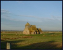
Fairfield in Kent lies between Brookland and Brenzett on a minor road in a deserted part of the Walland Marsh .

The area was won from the sea (inned) sometime between 1200 and 1270. The monks from Canterbury built dykes to the western edge of the Rhee Wall (the sea defenses built by the Romans) and enclosed the land so reclaiming the rich and fertile soil from the sea. 1287 saw the Great Storm in which Broomhill was swept away and New Romney barely survived. The Rother changed its course to the sea, and exited the marshes at Rye, whereas before the storm the river found its way to the sea near to modern day Greatstone and Littlestone .

Fayrefelde existed before 1595 as a map of the time shows the village approximately where the church now sits. It is likely that as the land became more reclaimed so the village sprung up. Nowadays all that can be seen is the church lying down from the road embankment which is probably the original inning wall. The church was built as a temporary structure of timber lath and plaster in the 1200's to support the local farming community. The exterior has been strengthened with brick, and in 1913 the whole building was reconstructed and encased to preserve it.

St Thomas a Beckett at Fairfield is one of those churches supported by the Romney Marsh Historic Churches Trust .
Views
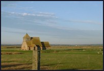
Fairfield in Kent church is very pretty lying alone in a field surrounded by sheep.

The views across the deserted ex marshland are very pretty.
Services
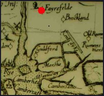
The church of St Thomas a Beckett holds services at 10am on the first Sunday of every month, further details can be obtained from the vicar.

There are no services at Fairfield in Kent , but about 2 miles away lies Appledore with its tea shops and other attractions.

The nearest trains to the area stop at Appledore station which is about 4 miles away.
Map
Fairfield is shown as the red symbol on the map.

Nearby Villages

(click on symbol to see the village page)
Village= Town= Recorded in Domesday=
Appledore (Danes invade England)
1.93 miles
Brenzett (St Eanswyth a saxon princess)
2.48 miles
Brookland (13th century wooden spire)1.69 miles
East Guldeford (Barn-like Church)3.71 miles
Iden (Sheriff of Kent and Jack Cade)
3.33 miles
Ivychurch (The burial ground on the Island)4.00 miles
Kenardington (Danes destroy Saxon Fort)3.82 miles
Lydd (The Cathedral of the Marsh)6.08 miles
Newchurch (The Church Tower with a kink)6.48 miles
New Romney (Cinque Port and Storm)6.36 miles
Old Romney (Sheep and Wool Smuggling)4.39 miles
Peasmarsh (Black Death moves village)5.56 miles
Playden (Saltcote and fish)
3.10 miles
Rye (On the Island)
4.68 miles
Smallhythe (The Ellen Terry Museum)4.87 miles
Snargate (Sluice Gates made by Royal Order)2.16 miles
Snave (the Remote church)3.74 miles
St Mary in the Marsh (Ancient Celts)6.47 miles
Stone in Oxney (Roman stone altar)1.69 miles
Warehorne (A good place to explore the Marshes)
4.07 miles
Wittersham (Park your Airship here ?)4.15 miles
Copyright Villagenet 1998-2024
 
Local Businesses
The Bald Explorer for local documentaries
For all things mosaic, commissions workshops etc please contact Hannah
Tenderheart Childrens Charity
The Rudes as lots of people call us, are an outdoor touring theatre company specialising in taking new & original theatre to mainly small rural communities and a few towns across the South of England. We were founded in 1998 & first toured in the Summer of 1999. Currently we tour only in the summer performing 50+ times nightly during June, July & August. https://therudemechanicaltheatre.co.uk
Talk in Code fabulous new Album
Battle Brewery our local excellent micro brewery