| |

|
|
|
| |
 Newchurch in Kent lies in one of the oldest parts of the Romney Marsh . The Romans
created the Dymchurch Wall and the Rhee Wall which protected the harbour
at Lympne . The land between originally used to provide salt to the legions
became slowly filled with alluvial deposits and turned into rich farmland. Newchurch in Kent lies in one of the oldest parts of the Romney Marsh . The Romans
created the Dymchurch Wall and the Rhee Wall which protected the harbour
at Lympne . The land between originally used to provide salt to the legions
became slowly filled with alluvial deposits and turned into rich farmland.
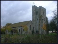
The church was started in the 1200's with the tower being started about 1410
however because the land around is reclaimed silt, the tower started leaning
when the second stage had been completed. Buttresses were added to stabilise
this and the top of the tower was added in 1480 this was built perpendicular
to the ground. Because of this the church tower has a major bend in the middle
with the lower two sections leaning to the west.
The village is in quite an isolated position, and was a centre for the sheep
and wool trade . Because of this owlers would frequent the area to obtain
the wool for its illegal export. It is likely as with most of the other
Marsh churches, that smuggled goods would have been stored in the church,
the most likely gang to do this would have been the Aldington Gang who were
based at Aldington just inland from Newchurch .
St Peter and St Paul at Newchurch is one of those churches supported by the
Romney Marsh Historic Churches Trust . |
|
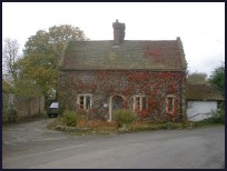
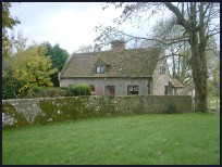 The church is unusual with the bend in the tower, it is also very old and
is nice just to visit. The buildings around the church give an ancient feel
to the area. The church is unusual with the bend in the tower, it is also very old and
is nice just to visit. The buildings around the church give an ancient feel
to the area.
All around lie the flat lands of the Romney Marsh , with their dykes, and
rich farmland, a pleasant place to ride around on a summers day. |
|
 Newchurch in Kent has very few village services, and to get anywhere requires a car. Newchurch in Kent has very few village services, and to get anywhere requires a car.
Hamstreet about 4 miles north has the nearest shops and facilities, and
also the nearest train station.
Ashford about 8 miles north has the full range of shops, supermarkets and
also the Eurostar train service to Brussels and Paris . |
|
| Newchurch is shown as the red symbol on the map. |
|
|
Nearby Villages
(click on symbol to see the village page) |
| Village= | |
Town= | |
Recorded in Domesday= |  |
| |
|
|
Aldington |
(The Aldington Gang) | | 3.30 miles |
|
|
Appledore |
(Danes invade England) | | 6.33 miles |
|
|
Bilsington |
(The Priory and Obelisk) | | 2.19 miles |
|
|
Bonnington |
(Saint Rumwold the child saint) | | 2.36 miles |
|
|
Brenzett |
(St Eanswyth a saxon princess) | | 4.19 miles |
|
|
Brookland |
(13th century wooden spire) | | 5.29 miles |
|
|
Burmarsh |
(The fortress in the Marsh?) | | 3.04 miles |
|
|
Dymchurch |
(The Romans and the sea wall) | | 3.14 miles |
|
|
Fairfield |
(The Isolated Church) | | 6.48 miles |
|
|
Hamstreet and Orlestone |
(The Start of the Ordnance Survey) | | 4.29 miles |
|
|
Ivychurch |
(The burial ground on the Island) | | 2.94 miles |
|
|
Kenardington |
(Danes destroy Saxon Fort) | | 5.33 miles |
|
|
Lympne |
(From Roman Castle to Tigers) | | 4.61 miles |
|
|
Old Romney |
(Sheep and Wool Smuggling) | | 4.12 miles |
|
|
Ruckinge |
(Smuggling and Traction Engines) | | 2.35 miles |
|
|
Snargate |
(Sluice Gates made by Royal Order) | | 4.34 miles |
|
|
Snave |
(the Remote church) | | 2.81 miles |
|
|
St Mary in the Marsh |
(Ancient Celts) | | 2.31 miles |
|
|
St Marys Bay |
(Holidays and Beaches) | | 3.29 miles |
|
|
Warehorne |
(A good place to explore the Marshes) | | 4.16 miles |
|
|
Woodchurch |
(Dragoons capture Smugglers) | | 7.04 miles |
|
|
| Copyright Villagenet 1998-2025 | |
| |
|
|
Local Interest
Just click an image |
|
|
|
|
|
|
|
|
|
|
|
|
|
|
| |