Hamstreet lies in the parish of Orlestone and is located on the A2070
Rye to Ashford road, about 7 miles from Ashford just on the edge of
the Romney Marshes .
William the Conqueror gave the Lordship of Orlaveston to Hugh de Montfort
after the Conquest in 1066 . It is believed that the De Montforts were
relatives of Simon de Montfort who defeated Henry III at the Battle of
Lewes .The church at Orlestone was probably built by the De Montforts
in the 1100's and extended in the 1300's.
It is believed that much of the population moved away from Orlestone
after the great Plague in 1352 , although the fresh water springs at
Hamstreet could well have been the actual reason for the shift lower
down the hill.
Hamstreet features on a set of four stamps issued by the Royal Mail in
1991 to celebrate the 200 years of the Ordnance Survey. In 1784, French
and British Astronomers had an argument over the longitute of the Greenwich
and Paris observatories. The argument was settled by measuring the positions
by triangulation from the two observatories, and Hamstreet lies very close
to one of the triangulation points.
In 1804 Napoleon was getting ready to invade England, the government
decided to try to stop a French invasion via the Romney Marshes and
they built the Royal Military Canal as part of the nations defenses.
It was re-fortified in the 1940's by installing gun emplacements and
pill boxes to try to delay a German invasion via the Marshes, the
canal runs through Hamstreet .
Views
The best views in Hamstreet are from the top of the hill near to
the church at Orlestone across the vast expanse of the Romney Marshes.
The old church again at Orlestone is a very attractive and peaceful place.
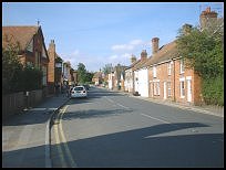
Hamstreet village has a nice high street, with weatherboarded houses,
and there are some good views across the marshes from the southern edge
of the village.
Services
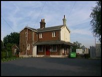
The village is on the Ashford to Hastings railway which runs across the
Romney Marshes via Appledore and Rye .
There is a bus service through the village providing a regular service.
A Primary school and a number of local shops are available for shopping,
however the main shopping centre is in nearby Ashford .
Map
Hamstreet And Orlestone is shown as the red symbol on the map.
Nearby Villages (click on symbol to see the village page)


 Hamstreet lies in the parish of Orlestone and is located on the A2070
 The best views in Hamstreet are from the top of the hill near to
the church at Orlestone across the vast expanse of the Romney Marshes.
The best views in Hamstreet are from the top of the hill near to
the church at Orlestone across the vast expanse of the Romney Marshes.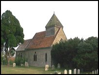 The village is on the Ashford to Hastings railway which runs across the
Romney Marshes via
The village is on the Ashford to Hastings railway which runs across the
Romney Marshes via